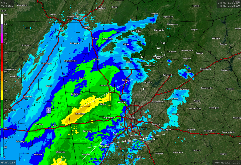
Good Tuesday morning! Winter weather rain drops are upon us and more is on the way. Our fast moving weather system has the pedal to the metal as the back edge of the meaningful precip as already exited Alabama. Rain should change over to snow in the higher elevations above 2000 feet pretty quickly. After that it’s pretty much a crap shoot on timing as the moisture will be exiting quicker than earlier expected. If we do change over to snow here in the lower elevations I’m not expecting anything more than a dusting or so on grassy areas. Also I don’t think black ice will be a problem for 95 percent of us as the sun will come out this afternoon and the winds will pick up so things should dry out. The other 5 percent is for those extremely hard to dry out places where a few icy patches could develop this evening.
FYI…all this precip across north GA on the radar is falling in the form of snow from it’s origins about 7500 feet up. It’s the lower levels that need to cool off a bit before the flakes can actually make it to the ground before melting.
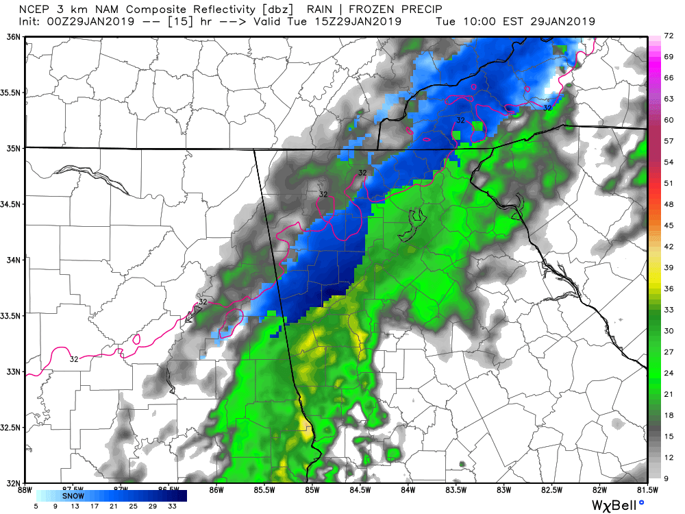
Tomorrow is going to be frustrating to watch if your a snow fan in Dahlonega. The way this whole system is setting up, areas south east and east of the spine of the Apps will be the last places to change over to snow as the lowest level of the incoming cold air literally gets hung up on the mountains. From this models projected radar image for 10a Tuesday, you can see how the colder low level air banks up against the mountains and then drains around Dawson county and then south. Places like Cobb county near Atlanta will likely change to snow before the city of Dahlonega because of this. It is what it is and this was known about this setup thus the higher potential snow totals for places north and west of the mountains. By noon all the precip should be gone and the sun coming out so we have a tight window here in Dahlonega to get our snow.
If you need any other particulars please read my other post I made earlier this evening. Thanks for reading and updates will flow tomorrow as necessary.
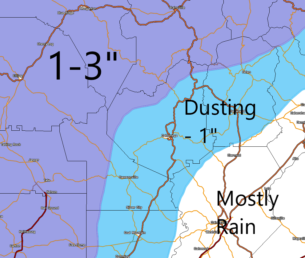
This update will be only about our snow chance on Tuesday. If your looking for the rest of the week you will need to check out my update that I posted yesterday. I’ve attached the same snowfall map to this post that I created yesterday. A few things have changed since yesterday. Pretty much all the high resolution short range guidance has all but punted with this system. The large scale global models continue to display something similar to my projected snow map. This whole deal is already razor thin on the boom or bust factor. With that in mind I think we will end up on the lower end of the range in each shaded area. What that means is closer to a dusting versus 1 inch for the bulk of us and closer to 1-2 inches versus 3 for all the areas north and west.
One trend that has happened on all the models is to be just a tad warmer at the start of the precip. That could make the transition to snow take longer and we are already in a tight window of moisture opportunity. Truthfully I have to basically throw out the high res short range models completely in order for me to believe may snowfall map is even possible. I’ve seen some pretty big busts over the years and this has the potential to be one of those. And we are now under an official winter storm warning and schools have been cancelled. Ugg….
Also people have been asking me able black ice and I just don’t think that’s going to be an issue for 95 percent of us due to winds and afternoon sunshine. But those isolated shady spots could develop some ice by Tuesday night.
Here is the timing as I see it now. Rain starts in the form of drizzle and showers after midnight. By sunrise the band of moisture should be knocking on the door with our temps in the low 40s. Yep 40s. Rain should transition to snow between 9-10a and last until maybe noon. And that’s it. Accumulation will be difficult due to above freezing temps…unless your in the darker shaded areas.
Now remember…this is based on me completely ignoring pretty much all the short range models and that’s a scary thought personally. We shall see….
Now it’s basically just watch the radar out in Arkansas and Mississippi as the precip breaks out and slides east.
I hope you get to enjoy our warmer temps today and Monday as cold air returns Tuesday. As I discussed on Friday the Polar Vortex is going to drop down into the upper midwest just reinforcing our below normal temps while placing the northern states under life threatening cold weather. Good news for us regarding the vortex is that it’s going to slide east versus south once it enters the US so our area will be spared from what it could have been.
Now the main talk is about the snow potential with the arctic front. We are less than 48 hours away from the weather start time and the models have decent agreement on what is likely to happen. The arctic front will clear our area around sunrise Tuesday morning. With the way the upper levels are setting up, there will be plenty of moisture behind the front overriding the cold air that’s moving in. What I expect to happen is for the precip to arrive with the cold front in the form of rain around 7am (ish) Tuesday. Within an hour or two the rain should change over to snow (quicker in the higher elevations and areas to our north and west). That will leave us with about an hour or two window for snow to fall. Accumulation will be a challenge as temps will have to fall to allow the accumulation to happen. Again higher elevations and areas north and west of the mountains will get there quicker thus more snow for those places. Either way this is a quick moving event with maybe only a 4 or 5 hour window of precip. All the precip should be over by noon. So we have a tiny window to get accumulations and it will be difficult. That is why I’m going with dusting to 1 inch for the majority of use with 1-3 for the higher elevations and areas north and west of us.
Things could trend in the direction of moisture which would equal more snow. It doesn’t take a whole lot of change in the projected upper level pattern to really ramp things up and that could happen. One more adjustment could be made tomorrow after we get the current weather system affecting FL today out of the way. If the system digs just a little deeper to our west then we would get more moisture. If it digs a little less than my map will be in jeopardy. LOL.
Either way I don’t we will see snow fall and colder air is once again on the way. With that in mind here is the forecast.
Today (Sunday)…mostly cloudy with a high in the low 50s.
Monday…morning low in the low 30s with a slight chance of a late afternoon shower. High in the low 50s.
Monday night…turning cloudy with temps steady in the low 40s.
Tuesday…rain changing to snow in the AM with temps falling below freezing by mid to late afternoon.
Wednesday…morning low in the low 20s. Mostly sunny high in the upper 30s.
Thursday…morning low in the upper teens. Mostly sunny high near 40.
Tuesday through Thursday will be breezy at times with winds gusting to near 30.
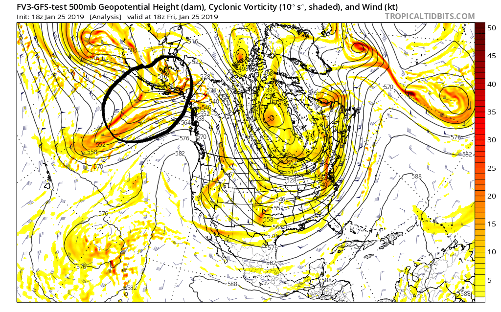
Ok…I’ve been trolling the local ATL weather personalities Facebook pages and have seen also sorts of confidence of what is GOING TO happen Tuesday. This is why I mention stuff and don’t hype it up. The area in the circle is the upper level piece of energy that will be responsible for whatever happens on Tuesday. As you can see it’s located in the Gulf of Alaska. Any area that is not over land is data sparce regarding actual data sampling of the atmosphere. Basically what that means is the PREDICTED event on Tuesday is based on computer models that have pieces of energy over areas that are not samples to its maximum. Our piece of energy will not be over land until Sunday when it will be sampled properly. Often we see decent shift up until 2 days out and this is the reason. So anyone saying that their confidence is growing is basing that on energy that is minimally sampled. Personally I think the best course of action is to mention the potential and wait until maximum data is available before making any sort of irrational posts or predictions. More often than not this ends up being the best method.
We are well entrenched in the pattern change I mentioned last week where the warm ups will be brief between cold fronts. Another cold front moved through yesterday which will set the stage for mostly tranquil weather through most of the weekend. Only Sunday will feature about a 20 percent chance of a shower but more than likely we get nothing.
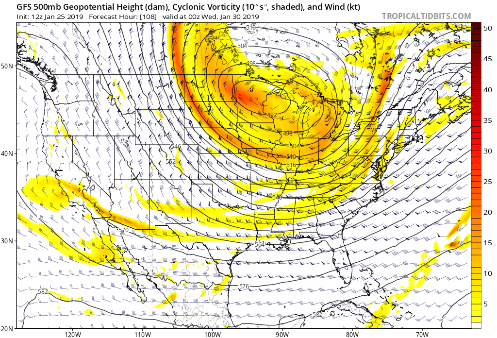
Next up will be some major cold air across the eastern half of the country. All indications are that the polar vortex will drop down into the Great Lakes area come Tuesday. The image I attached to this post shows the potential location of the vortex. Temps will be just absolutely bitter cold pretty much everywhere north of Tennessee. We will feel the effects also with two strong cold fronts but the bulk of the worst of the cold will remain to our north. It’s still going to be cold here Tuesday onward though for sure.
Now of note of interest is the cold front that will be moving through Tuesday morning. Normally with a cold front all the moisture is out along and ahead of it. In this situation the bulk of the precip should be behind the cold front. And since the air behind the front means business, there is a shot at the precip turning over to snow before it ends. This system is 4 days out so much will likely change but its within 5 days so in my world the system has entered into the area of what I call the Realm of Possibility. Remember my rule of thumb is anything 5 plus days out is called fantasy land so we are out of the phase. Now we have something to track. Some guidance says we are going to have a hey look at those flakes falling kind of event and some says more. This is way way too early to call so don’t believe anything you see out there right now that says we ARE GOING TO GET x number of inches. Nobody in their right mind should be stating this like that for us…at this point in time. If by Sunday afternoon I’m still tracking this system then we should have more specifics to talk about. Until then enjoy our continued below normal temps.
With that in mind here is the forecast…
Tonight…clear and cold with lows in the mid to upper 20s.
Saturday…high clouds increasing late with a high in the mid to upper 40s.
Sunday…mostly cloudy with a 20 percent chance of a shower and a high in the mid to upper 40s.
Monday…mostly sunny with a high in the mid 50s.
Monday night…increasing clouds with a low in the low 40s.
Tuesday…cloudy with rain possibly changing to snow showers. Turning windy with temps falling below freezing during the afternoon.
Wednesday…sunny and chilly with a low in the low 20s and a high in the upper 30s.
Thursday…cold with a low in the low teens and a high in the low to mid 30s.
Friday…sun though high clouds. Morning low in the low 20s and a high in the low 40s.
Good Saturday morning everyone! We are on the eve of an overall pattern change. A strong cold front is going to blast through tonight (Saturday night) ushering in much colder air. Ahead of the front today we can expect rain that will be heavy at times and possibly a thunderstorm. I’m not expecting any severe weather. The winds could get quite gusty out of the south this afternoon especially if you live in higher elevations.
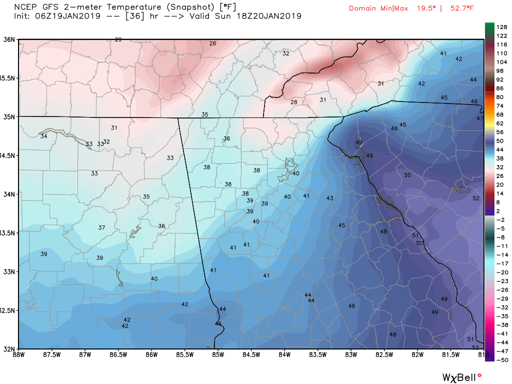
The front should pass the area sometime near or shortly after midnight putting an end to the rain. Behind the front on Sunday expect gusty winds and temps in the 30s pretty much all day long. The image attached to this post shows what it could look like at 1p tomorrow (Sunday). Brrrr……. There is a shot of a few scattered snow flurries with a dusting or so possible along and north of the spine of the apps. (Suches, Blairsville, etc).
Now this front will be the lead to an overall pattern change where we will see more frequent cold fronts as an overall ridge dominates out west while the trough sets up in the eastern half of the country. For Monday and Tuesday expect highs in the mid 40s with lows in the mid to upper 20s.
Another front is set to approach the area on Wednesday bringing warmer air ahead of it and more rain starting Tuesday night lasting into the Thursday AM hours.
That’s it for now and there are no legit snow threats to track but as we get deeper into this pattern that could change.
Rain rain go away!!! Good news is that all these clouds and showers and drizzle will finally exit stage right for at least Tuesday and Wednesday and the better part of Thursday. Sunshine will be the dominate weather feature which will be super nice. Temps this week will be 5-10 degrees above normal each day. Enjoy that because it appears that a pattern change is on the way this weekend.
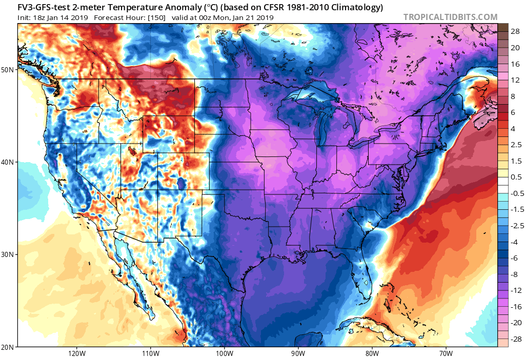
The graphic I posted shows the potential temperature departure from normal Sunday evening. You can pretty much see that everywhere east of the Rockies is going cold. This should be the beginning of an overall pattern change where colder than normal weather should dominate the eastern half of the US. For those of you who like to follow weather apps, you will probably see some nutty temps and weather show up for parts of next week. Don’t get caught up in those details as surface weather features can’t be nailed down that far out. The main takeaway is that a major pattern change looks to be on the table. The rest will work itself out. People ask me all the time about when it’s going to snow. Well if the pattern isn’t right then it takes a perfect timing miracle which happens every now and then. But when the pattern is right then you have to look for that weather system. I always say first we need the weather pattern then we can start looking at the details (within a 5 day range).
Well I think the pattern is going to come around with the cold front that is going to blast through here early Sunday. Then the following 7-10 days or more should feature multiple strong cold fronts and weather systems that will need to be closely tracked.
With that in mind here are the details…
Tuesday and Wednesday…sunny with highs in the low to mid 50s after morning lows in the upper 20 to low 30s.
Thursday…becoming cloudy with rain showers likely by late afternoon or evening. Rain should last into Thursday night.
Friday…clearing skies with a high in the upper 50s.
Saturday…becoming cloudy with showers or drizzle likely. High in the upper 50s.
Sunday…Rain ending early then clearing and turning windy with temps falling below freezing during the afternoon.
Most areas are just a tad above freezing. I’m expecting temps to hold steady or slowly rise overnight. We dodged a bullet thankfully! Forecasting is a fine line where just a degree or two in either direction changes everything. Thankfully everything has progressed as expected so far.
Most areas are just a tad above freezing. I’m expecting temps to hold steady or slowly rise overnight. We dodged a bullet thankfully! Forecasting is a fine line where just a degree or two in either direction changes everything. Thankfully everything has progressed as expected so far.