Good Sunday afternoon everyone!
I hope you get to enjoy our warmer temps today and Monday as cold air returns Tuesday. As I discussed on Friday the Polar Vortex is going to drop down into the upper midwest just reinforcing our below normal temps while placing the northern states under life threatening cold weather. Good news for us regarding the vortex is that it’s going to slide east versus south once it enters the US so our area will be spared from what it could have been.
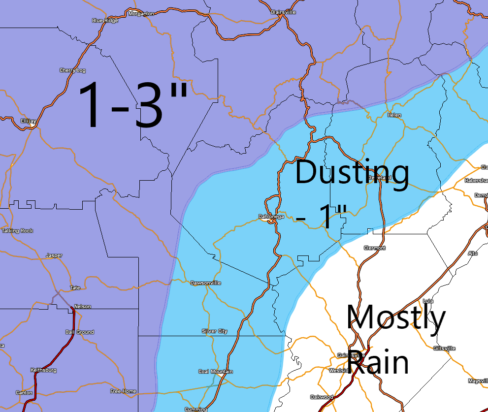
Now the main talk is about the snow potential with the arctic front. We are less than 48 hours away from the weather start time and the models have decent agreement on what is likely to happen. The arctic front will clear our area around sunrise Tuesday morning. With the way the upper levels are setting up, there will be plenty of moisture behind the front overriding the cold air that’s moving in. What I expect to happen is for the precip to arrive with the cold front in the form of rain around 7am (ish) Tuesday. Within an hour or two the rain should change over to snow (quicker in the higher elevations and areas to our north and west). That will leave us with about an hour or two window for snow to fall. Accumulation will be a challenge as temps will have to fall to allow the accumulation to happen. Again higher elevations and areas north and west of the mountains will get there quicker thus more snow for those places. Either way this is a quick moving event with maybe only a 4 or 5 hour window of precip. All the precip should be over by noon. So we have a tiny window to get accumulations and it will be difficult. That is why I’m going with dusting to 1 inch for the majority of use with 1-3 for the higher elevations and areas north and west of us.
Things could trend in the direction of moisture which would equal more snow. It doesn’t take a whole lot of change in the projected upper level pattern to really ramp things up and that could happen. One more adjustment could be made tomorrow after we get the current weather system affecting FL today out of the way. If the system digs just a little deeper to our west then we would get more moisture. If it digs a little less than my map will be in jeopardy. LOL.
Either way I don’t we will see snow fall and colder air is once again on the way. With that in mind here is the forecast.
Today (Sunday)…mostly cloudy with a high in the low 50s.
Monday…morning low in the low 30s with a slight chance of a late afternoon shower. High in the low 50s.
Monday night…turning cloudy with temps steady in the low 40s.
Tuesday…rain changing to snow in the AM with temps falling below freezing by mid to late afternoon.
Wednesday…morning low in the low 20s. Mostly sunny high in the upper 30s.
Thursday…morning low in the upper teens. Mostly sunny high near 40.
Tuesday through Thursday will be breezy at times with winds gusting to near 30.
Thanks for reading!
Jason