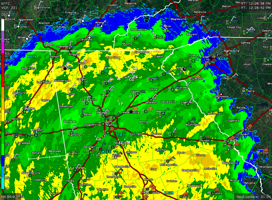
The affect of Tropical Storm Irma are staring to increase. So far I’ve recorded several winds gusts over 30 mph and that will only increase as we head through the afternoon. Irma is currently just across the GA/Fl border tracking to the NW. The rest of the day Irma will move towards Columbus and then into western Alabama. Rain, heavy at times, will continue to rotate into our area and give us widespread 2-4 inch amounts.
Now the greatest impact will be the high winds which will likely cause power outages around the area. The greatest threat will be from about 5pm until 10pm as that is when the winds are expected to peak with gusts to 50+ mph. Perhaps some higher gusts will occur at elevations over 3,000 ft. Right now we are pretty much in Nowcast mode where we just wait for everything to unfold and happen as expected. So far everything is going as expected.
Stay safe and updates will continue to flow.
Jason
Elcaptain Blaze
thanks!
Thank you for keeping us updated, Jason! You are appreciated!
Thanks for the update.
Thanks Jason. Appreciate ya.
Thanks Jason!
Thanks for keeping us updated, we really appreciate what you do.
Thank you Jason!
Thank you!
Thanks for keeping us informed!
Thank you, appreciate you looking out for us and keeping us informed
Thank you Jason.
Hang on & stay put, it’s gearing up … 🙁
Just waiting.
Thanks Jason!
Very little wind here, a good thing!
Yeah your on the good side of the chain this time. Enjoy it.
WILD here in Young Harris at 20:15 … likely since in this valley.
Thanks for the update!
Button down the hatches, Nadings!
Will do, just rain and light wind now, hopefully the worst will be behind us by 10p this evening
Don Nading , I guess that should have been “batten” down the hatches? Glad you are safe and sound!
Patty Robinson Spriggs 😊😊, autocorrect 😉
Angie Tanksley
Thank you Terri!
Thank you very much!! 👌
thanks, Jason!
Desiree Fernandez-Griffin Lucero Robles
Thanks for all the updates, will be watching this page.
Todd Anderson
Thank you so much Jason!! I rely on your forecast more than anyone on tv! You tell it like it is and that’s exactly what we need! 😊
Debbie Miller
Appreciate your updates!
Thank you.
Thank you! (Ps..Lumpkin schools already cancelled tomorrow)
They did?!?! Thanks I had no idea.
Thanks for the great update. Even though it’s calm now.. Please keep us posted. I have severe storm anxiety!!
You have calm wind? I’m constantly gusting to near 30.
that flag gives ME anxiety!
Esborn Rd residents count on your info….Thanks!!
Justin Talton
Thsnk you!
Leland Turner
Andreas Bowers follow this page for updates.
Thanks Jason
So are we gonna have lots of crazy wind?
Currently getting gusts into the 30s. You?
Just left work on Crown Mountain it was pretty nuts
Worst should be from 5p to 10p. So we have yet to get to the worst of this.
So after 10pm getting better?
Yes
Thanks for the updates.
we are still …no wind…calm…here in Blairsville
Yeah Blairsville isn’t supposed to get high winds. Count your blessings. 🙂
It’s very calm here, off Mill Creek Church, too. Just rain and very little wind.
Hard to believe you have little wind while I’m gusting over 30mph frequently. Weird indeed…
We’re kind of in a hole? Maybe that’s why we’re not seeing that much wind… But it has been mostly calm all day.
James Dowdy
Thanks!
Thank you for the updates Jason. It is appreciated. I always look to Dahlonega weather for the every day forecast.
Here off Old Dahlonega Hwy we are experiencing gusting winds. Very little rain right now.
I am glad I got home from work an hour ago. Be safe everyone.
Getting some strong gusts about a mile down Washega/ Camp road. Just heard a loud boom that shook the house. Must have been a very large tree falling somewhere close.
I live off of Siloam church road on the top of a steep hill. Power is out. But the wind is completely terrifying where I’m at.
Be safe