We are flirting with the freezing mark as heavier rain approaches. I would not be surprised if we dip below freezing a bit and get some minor icing on elevated surfaces. Suches is already below freezing and stands to get more icing than the majority of us.
Just wanted to post a quick update to our weekend weather. My thinking on this whole system has not changed since my update yesterday. The majority of our weather will be a cold rain. And when I say cold, I’m talking about mid 30s cold. There is a chance that the rain will start off as a mix of sleet or snow or both as it arrives midday on Saturday. The mix (if the mix even happens) could last a few hours before becoming primarily just a cold rain. We will be flirting with freezing temps by Saturday evening so it will need to be watched closely.
As I outlined yesterday, I think there is a decent chance of wintry precip lasting longer for the higher elevation mainly above 2,500 feet. That basically means areas along and north of the spine of the apps. (i.e. Suches). For this reason the Weather Service out of Peachtree City has issued a Winter Weather Advisory for the higher elevation areas. This excludes the bulk of us. The graphic posted outlines this threat pretty well I think.
Now as I mentioned we will be flirting with temps in the low to mid 30s Saturday afternoon and evening. Right now the most likely scenario is just a cold rain. But if temps get just a few degrees colder than I expect then we could be dealing with some minor freezing rain the first part of Saturday night. Right now I’m banking on that not happening to any amount of significance for areas below 2,500 feet.
Either way the cold rain exits early Sunday morning before more showers encroach the area on Monday.
Seasonal temps have returned. I think we will likely be normal to below normal for the next seven days or so. We have two more fantastic days (Thursday and Friday) before a gloomy, chilly, wedge day sets up for Saturday.
I know there have be rumors and talk of winter weather. Once again this will be a mostly cold rain event. Rain should arrive sometime near or shortly after noon on Saturday and last into Sunday and possibly Monday. Now there is the potential for some brief mixed bag precip at the onset and during Saturday evening for areas above 2500 feet in elevation which is the usual along the spine of the apps in the higher elevations. Most likely scenario is for the rain to possibly be mixed with some sleet or snow at the start before it quickly changes to just a plain cold rain. The mixed precip could hang on into Saturday evening for elevations above 2500.
With that in mind here are the details…
Today (Thursday)…sunny and chilly with a high in the mid 40s.
Friday…after a morning low in the upper 20s a sunny high in the upper 40s.
Saturday…cloudy with a morning low in the low 30s. Rain or mixed precip developing during the afternoon hours. Any mix precip to become just cold rain. High in the upper 30s.
Saturday night…cloudy with a cold rain. Low in the mid 30s.
Sunday….mostly cloudy with scattered showers possible. High in the upper 40s.
Monday…cloudy with scattered showers possibly mixed with snow in the higher elevations. High in the low 40s.
First off this will be my last update until after Christmas so Merry Christmas!
Teaser snow fell on Saturday in the higher elevations which is pretty cool. Eventually we will get a system to track that should impact everyone! But patience until that presents itself.
Up next is a weak area of low pressure that will track across the TN valley today(Sunday). This will bring clouds and scattered showers this afternoon. Rain chance is about 50 percent. As the low departs it will drag a cold front through the area leaving us with plenty of sunshine for Christmas eve and Christmas Day. Temps both Monday and Tuesday will be just about normal with lows near freezing and highs at or just above 50. There is a zero chance of a white Christmas. Sorry…
Another weather system starts to approach our area on Wednesday increasing clouds before rain arrives once again for Thursday lasting into Friday. That has the looks of yet another 1-3 inch rain event.
I’m hope you have been enjoying the past few days above normal temps. It’s been a super nice break from our mostly chilly weather. But all good things must come to an end as rainy-cool weather returns Wednesday night.
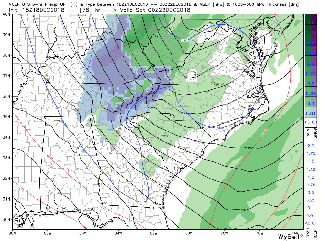
An abnormally deep trough is going to develop in the eastern US that will trigger the development of several areas of low pressure that will track across GA. The first one will bring rain starting Wednesday night into the first half of Thursday. Then as the trough really deepens another area of low pressure will develop and just reinforce the rain action that will last into Friday. There isn’t a whole lot of cold air with this system but conditions on the back side will be close to support some snow flakes mainly across the higher elevations of GA. This would be for the late Friday afternoon time period towards sunset. The posted image is what the precipitation type could look like come 7pm Friday. Now I’m not expecting anything major for us here is Dahlonega but a few flakes are possible. Elevations above 2,500 feet, which means basically along and north of the spine of the apps, could get some minor accumulation.
Either way everything clears out late Friday night leaving us with a pretty decent weekend.
Here are the details…
Wednesday…mostly cloudy with a high in the low 50s.
Wednesday night…rain likely with a low in the low to mid 40s.
Thursday…rain likely with a high in the upper 40s.
Thursday night…rain likely with a low in the low 40s.
Friday…showers likely possibly changing to flurries by late afternoon especially in the higher elevations. Becoming windy late afternoon. Temps steady in the low 40s and falling late.
Friday night…snow flurries possible early then clearing and windy at times. Low near 30.
Saturday and Sunday look to be mostly sunny with highs near 50.
Just a quick update. So far everything has almost gone according to plan. Next up is the return of showers with potential snow mixed in or all snow above 2500 feet. While I’m not expecting any accumulation for 95 percent of us, there could be an inch or two along and north of the spine of the apps. Sound familiar?
The radar may look pathetic right now (as of 11p) but that will change rapidly over the next 2 hours. Precip should linger into the early morning hours.
So far everything as progressed as expected expect I never hit freezing last night. If you’ve got an accumulations of anything frozen let’s hear about it.
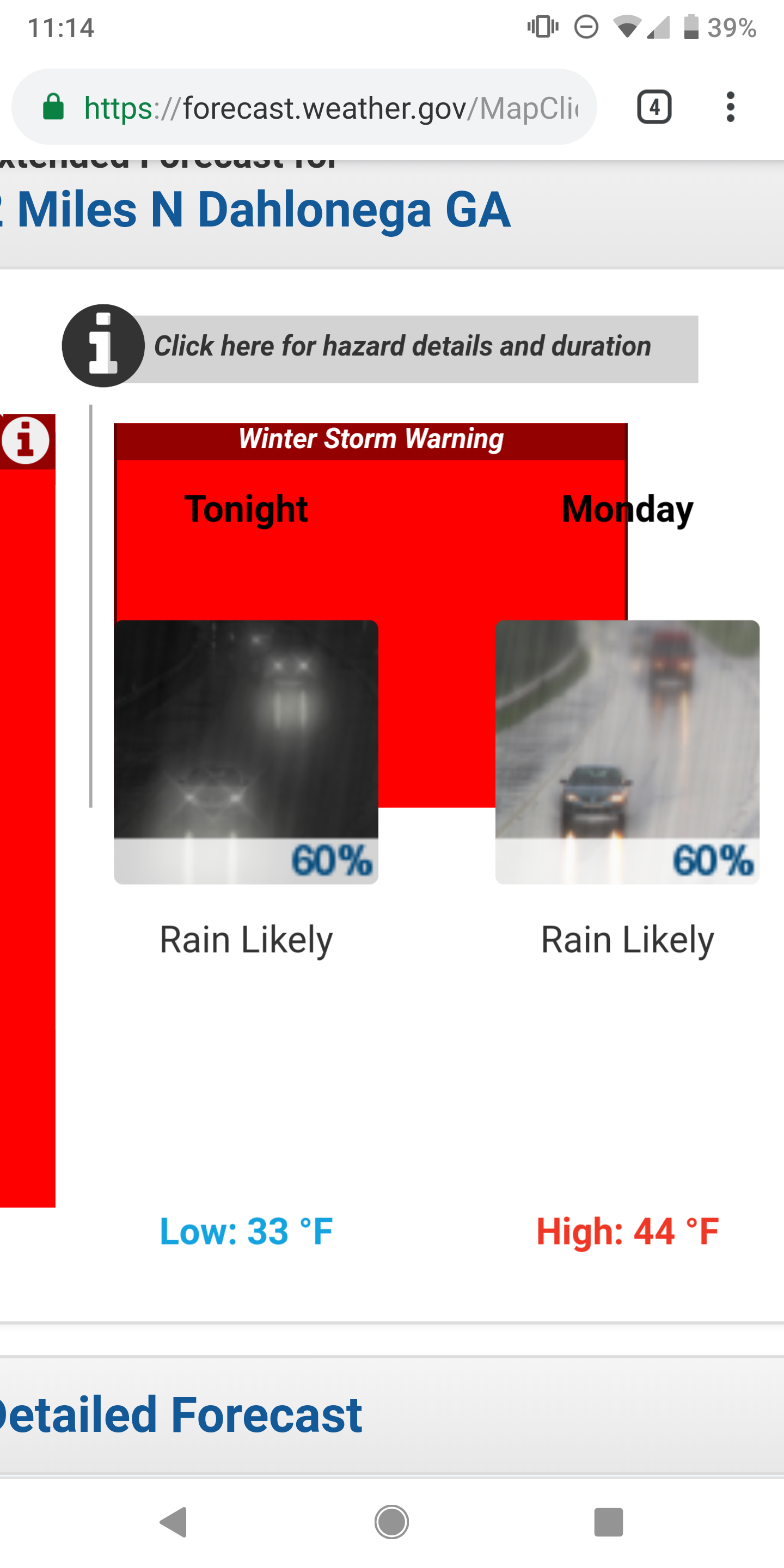
So far everything has progressed as expected. We are in the midst of our chilly cold rain day so enjoy that. Yes we are now under a winter storm warning per the National Weather Service out of Peachtree City. If you carefully read the warning text you see they mostly reference places above 2500 getting the best accumulation which aligns with my thinking all along.
Brand now model guidance is hot off the press and not a whole lot has changed. I do believe the chance of seeing more widespread snow tonight has increased…just a tad. It still looks decent for places above 2000 feet and along and north of the spine of the apps. Places like Suches should end up with probably 2-4 inches.
Here is how I think things will progress.
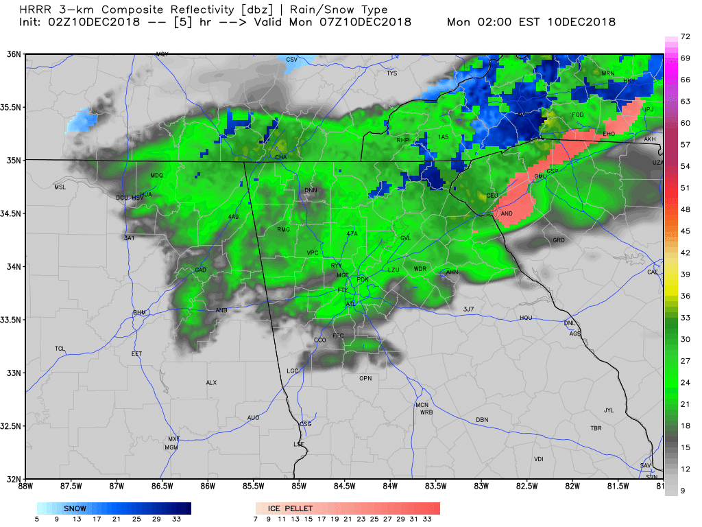
Today will feature mostly just a cold rain that’s heavy at times. During the heavier periods of rain I would not be surprised if some snow flakes mix in all around the area. As we progress through the night our best chance to see widespread snow will be in the window from around 10p-2a as the upper levels just might be good enough to allow the precip to change over. Again this is for all areas of Dahlonega. Higher elevations should get accumulating snow as I described in the paragraph above. Snow or not for the majority of us there should be a period of sleet and or freezing rain lasting until mid Sunday morning. Now if the precip ends up being more sleet then roads could be an issue. If it ends up more freezing rain then personally I think they will be just wet.
Sunday will continue the mix bag precip as showers could mix with or change to snow at times with no accumulation expected below 2000 feet elevation. Oh and if you want to know your elevation, just download a gps status app on your phone and it will tell you.
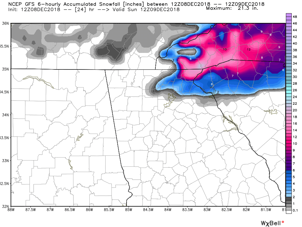
The mixed bag precip will continue into Sunday night before everything finally exits on Monday. Now what I laid out is what I think is the most likely scenario to happen. Theres always potential for this to over perform. The latest GFS snow map displays what I think this could look like IF IF IF IF IF IF IF IF IF IF IF IF IF IF it over performs and the system dynamics win out over the marginal upper level temps.
Also something that is useful is to download the mPing app on your phone and report your current conditions from time to time should the weather your experiencing change. It’s a cool and free app and you can see where it’s raining and or snowing based on ground reports.