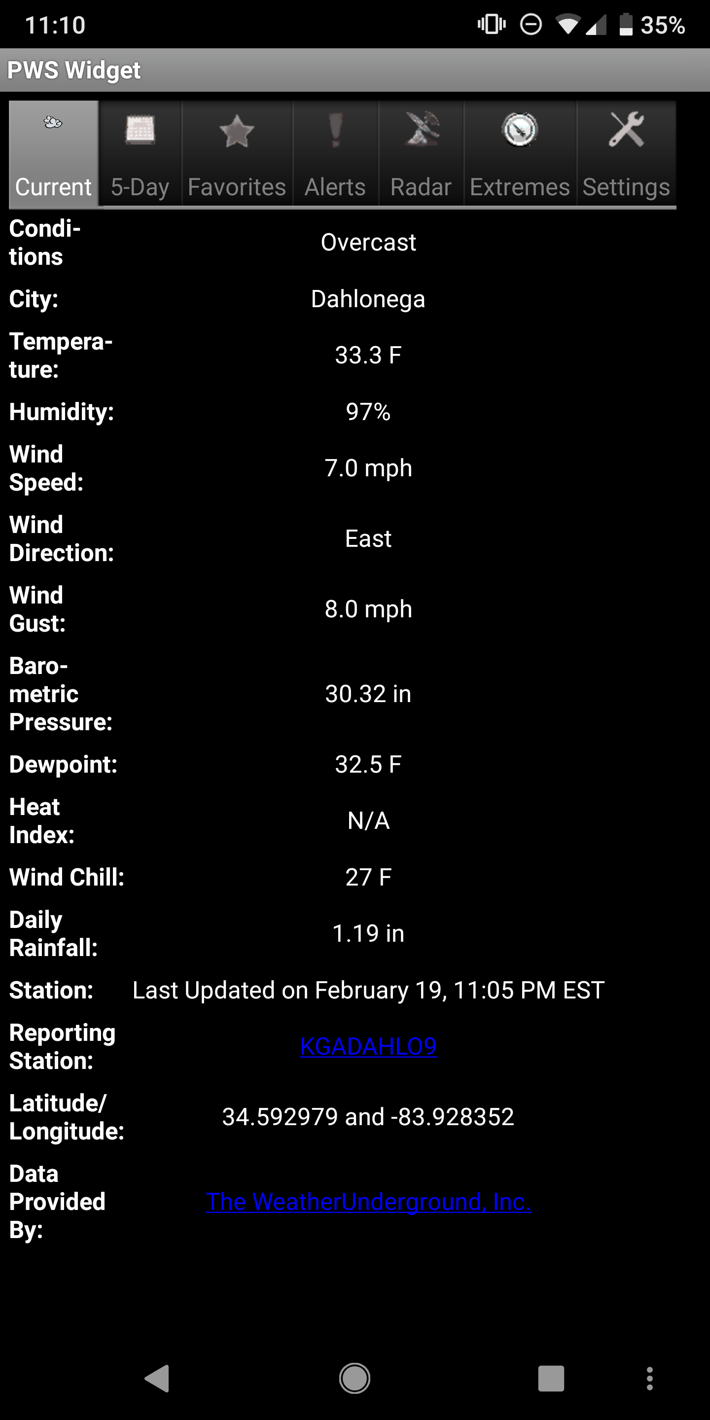
Today was our winter in a nutshell. You get a cold rain all day long. Heck even thunder and lightning. And now we sit at 33.3 with what…oh…rain. I’m done with this winter. Bring on spring.
Today was our winter in a nutshell. You get a cold rain all day long. Heck even thunder and lightning. And now we sit at 33.3 with what…oh…rain. I’m done with this winter. Bring on spring.
Don’t be alarmed by any sleet you see early this morning. It’s just the moisture overcoming the dry air just above the surface and won’t last long.
So who is excited at the prospects of yet another total rain out? Well your excitement will be rewarded tomorrow (Tuesday) with what should be a complete rain out. Oh and to top that off temps will be stuck in the 30s ALL DAY LONG. Patchy freezing rain is possible in the highest elevations in the mountains late tomorrow.
Enjoy!!!
Jason
As I mentioned earlier yesterday, we had a shot at breaking both our record high and record warm low temps for Feb 7th. Well that happened as we topped out at 73.9 breaking the old record of 71 set back in 1927. Our low yesterday was 60.8 also breaking the record warm low temp of 54 set also back in 1927. The cold front has already moved through so we should be done with record warm temp threats for a while.

We should break two more records today. Our record warm low for today is 54 and so far our low has only been 60. The record high for today is 71 and we should beat that. Both the previous records were set back in 1927. Colder weather returns starting Saturday.
With a low of only 54 degrees on Wednesday February 6th, we tied our record warm low of 54 set way back in 1927.
With a balmy high of 71.1 on Tuesday February 5th, we tied or rather just barely broke the previous record high of 71 set back in 1991.
Our friendly below normal weather pattern that has blessed us with plenty of chilly temps is going on a vacation starting this weekend. This map is the projected surface temp anomalies come Sunday. Basically everyone that is currently freezing is going to be thawing out. But fear not…cold weather will return.
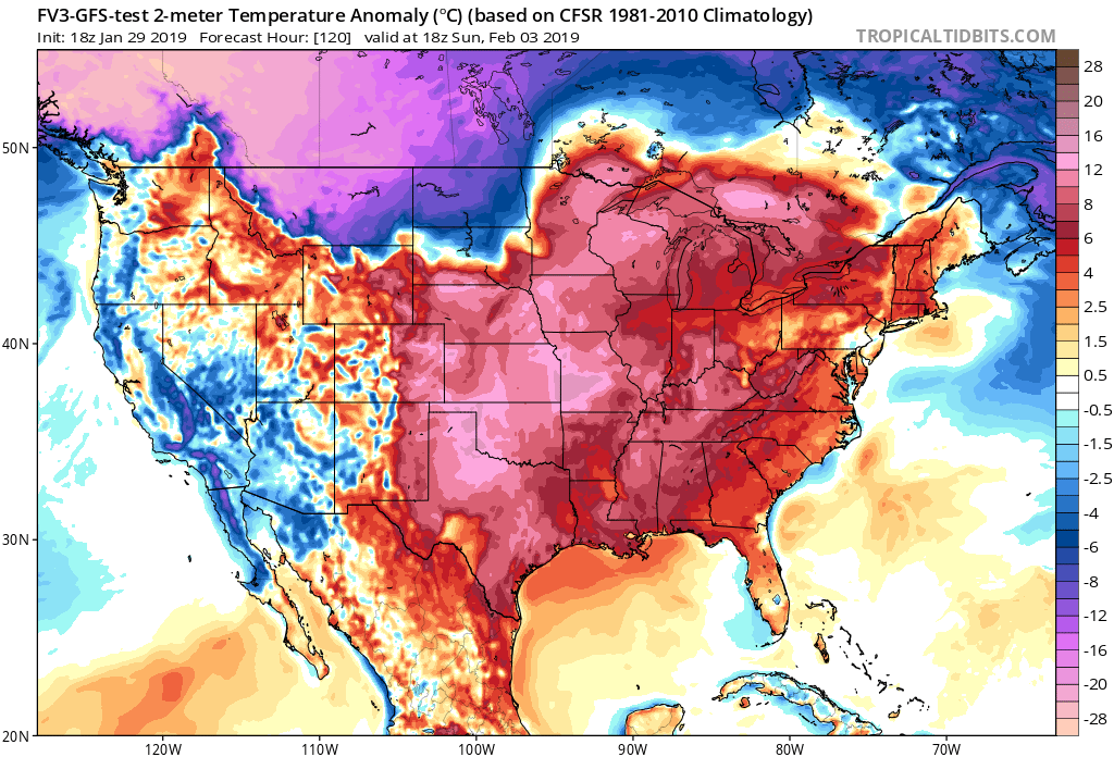
Our friendly below normal weather pattern that has blessed us with plenty of chilly temps is going on a vacation starting this weekend. This map is the projected surface temp anomalies come Sunday. Basically everyone that is currently freezing is going to be thawing out. But fear not…cold weather will return.
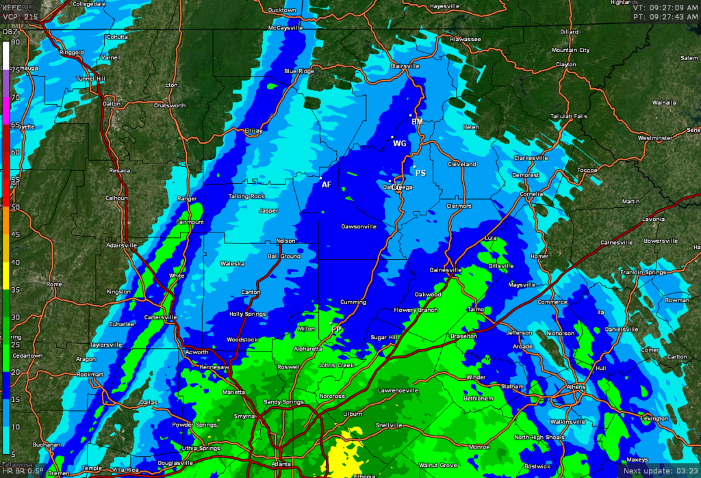
The back edge of the precip is rapidly approaching. Needless to say our window of opportunity for snow is shrinking really fast. I wasn’t expecting Dahlonega to see anything until around 10a onward. But the precip is getting out of here quicker so if you see any flakes in the lower elevations, they will just be for looks and not for real accumulation. Again I’ll restate that I’m not expecting any black ice issues for 95 percent of us.
Jason