Good muggy Friday everyone!
Heat and humidity are upon us and that story will continue through Sunday. Despite the clouds and scattered showers we are easily above or normal high for this time of year of 70. The main talk and chatter out there right now is the potential for severe weather on Sunday. An area of low pressure is going to develop back in Texas and rapidly intensify and then track NE through Arkansas and Missouri. As it tracks to our north, it will drag a front across the southeast which will fire up plenty of showers and thunderstorms. There is a decent amount of wind shear with this system (winds changing direction and speed with height) which will aid in the development of severe level storms.
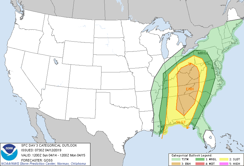
From the image below you can see that the Storm Prediction Center currently has us in the Enhanced risk category for severe weather on Sunday. While Enhanced is only in the middle of their scale, it is higher than what we normally see as typically we don’t see many instances higher than the Slight category.
So what does all mean exactly? Expect a higher than normal risk of a severe thunderstorm on Sunday. The mostly likely severe type of weather expected is strong winds and small hail. Now due to the wind shear with this system their is the risk of an isolated tornado or two that could develop anywhere across northern GA. So with that in mind, Sunday will be a radar watching day to see exactly where everything unfolds. When or where or even if a tornado will develop are simply impossible to predict. Just know that conditions will exist to allow for isolated tornado development. More often than not I simply shoot down our severe threats as we often have a wedge in place that saves the day. Sunday we will not have any sort of wedge so I’ll be keeping an eye to the sky.
With that in mind here is the forecast:
Today (Friday)…mostly cloudy and warm and humid with a 40 percent chance of a shower or thunderstorm. High in the upper 70s.
Saturday…partly to mostly cloudy with a 40 percent chance of a shower or thunderstorm. High in the upper 70s.
Sunday….read my post above.
Monday…sunny and breezy and cooler with a high in the low 60s.
Tuesday and Wednesday…partly cloudy with a high in the mid to upper 70s.
For those who have been asking about another freeze or frost, at this time I don’t see anything out there but we do have another decent cold front coming through on Friday the 19th. So if there is going to another chance it will be the few days after that.
Thanks for reading!
Jason