We are now under a Severe Thunderstorm Watch until 11pm. The primary threat will be strong winds and hail. Timing looks to be after 7pm for our area.
Here are the details from the Storm Prediction Center.
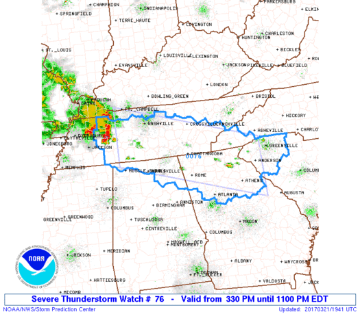
   URGENT - IMMEDIATE BROADCAST REQUESTED
   Severe Thunderstorm Watch Number 76
   NWS Storm Prediction Center Norman OK
   330 PM EDT Tue Mar 21 2017

   The NWS Storm Prediction Center has issued a

   * Severe Thunderstorm Watch for portions of
     Northern Alabama
     Northern Georgia
     Western North Carolina
     Western South Carolina
     Middle and Southeast Tennessee

   * Effective this Tuesday afternoon and evening from 330 PM until
     1100 PM EDT.

   * Primary threats include...
     Widespread large hail likely with isolated very large hail
       events to 2 inches in diameter possible
     Scattered damaging wind gusts to 70 mph likely

   SUMMARY...Strong to severe Thunderstorms are expected to develop
   across the watch area this afternoon and spread southeastward
   through the early evening.  Large hail is the main threat, but an
   increasing risk of damaging winds will also develop by late
   afternoon.

   The severe thunderstorm watch area is approximately along and 65
   statute miles north and south of a line from 60 miles south
   southwest of Clarksville TN to 20 miles southeast of Anderson SC.
   For a complete depiction of the watch see the associated watch
   outline update (WOUS64 KWNS WOU6).
What?!? But, it’s gorgeous outside!!
It won’t last
Damnit!
It never does….
Thunder storm north east of Murrayville, I can hear it.
Yeah just posted about it. Not related to the main system to come.
Yeah, looks to be a bruiser. 2″ hail… 70 mph wind gusts.
Thundering on black mountain rd
Meredith Seader
Omg
Was the worst storm I’ve seen in a good while…lightening, thunder, wind, hail….the works.