And yet more storms developing and tracking NE.

And yet more storms developing and tracking NE.

Good Wednesday evening everyone!
Another week…another strong weather system. Once again an upper level low (common in the spring) will track across the southeast. As you probably felt today, the humidity went way up as our dewpoint climbed back into the low 60s. But this time the high humidity will be short lived as the upper level low will bring a pool of cool air with it especially on Saturday.
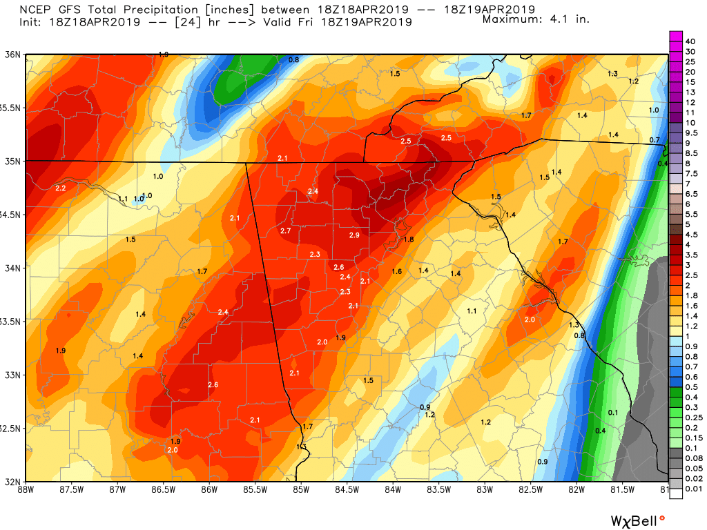
Now there have been talks of severe weather tonight. While conditions are not as favorable for any sort of tornado development they are more favorable for strong winds. A very strong low level jet stream, around 5,000 feet up, will be screaming across the area at 60+ mph in the early AM hours on Friday. When you combine strong winds like that aloft with a line of thunderstorms, then you are likely to see those storms transport some of those winds to the surface. So I’m expecting winds to gust to near 40 mph give or take during the 4a to 8a Friday time frame. And the rain should be very heavy at times during that same period. The image I posted is the GFS model estimated rainfall between now and 2pm Friday. Yep…1-2+ inches should be the story across the area with most of that falling between 4a and 8a Friday.
After the main line moves through in the early AM hours on Friday expect mostly cloudy skies with on and off showers and possibly another afternoon thunderstorm or hail producer as the cold core aloft starts to move across the area.
Now I also think there is the possibility of a few snow showers mixing in with the rain showers at elevations near or above 3000 feet come early AM Saturday. If some higher elevations got a dusting I would not be surprised. Again that is just for areas along and north of the spine of the mountains. Fret not though as we will warm back up super quick by Sunday.
Here are the details…
Tonight…heavy rain and storms with high winds likely after 4a tonight.
Friday…heavy rain moving off to our east during the AM hours then just mostly cloudy with on an off showers and possibly an afternoon hail producer. High in the mid 60s.
Saturday…mostly cloudy and breezy with scattered showers with snow showers possible above 3000 feet. High only in the upper 40s.
Sunday…sunny and warmer with a high near 70.
Monday…sunny with a high in the upper 70s.
Thanks for reading!
Jason
Thats a wrap folks. Severe threat is long gone. We ended up with 2.16 inches of rain which far exceeded expectations. At one point I recorded .43 inches of rain in 10 minutes. Nuts.
Now we turn windy and sharply cooler. Lows tonight in the low 40s with a high on Monday only in the low 60s.
Tuesday and Wednesday will be sunny and lows but low humidity.
Rain chances come back late Thursday into Thursday night before we cool off once again for next weekend.
I probably won’t post another update until Thursday…if then.
Jason
The Storm Prediction Center is eyeing issuing a new Tornado Watch of which we would likely be on the fringe. As I’ve been mentioning more scattered storms will develop, and they already are as of this post off to our west. It will not be a solid line like this morning but rather the storms will have spacing. Time of affecting Dahlonega will likely be in the 5-7p window.
Jason
Super heavy rain is on it’s way out of the county moving towards the NE. This should mark the end of round 1. Now we wait an see how the redevelopment happens come 3pm onward. There should be more scattered cells around the area from 4-6pm. These will need to be watched closely as well. This storm that just went through at 1pm had rotation aloft but it was weak.
Jason
Just a quick update.
The morning action is approaching right on schedule. This should arrive in the 10-11a time frame and last for an hour or two. Primary threat will be strong winds and small hail. Still my main concern is for later this afternoon towards 5-6pm as isolated cells should develop along the cold front. Its in my opinion that will be the highest risk for a tornado somewhere in north Georgia.
Jason
Good Saturday morning everyone!
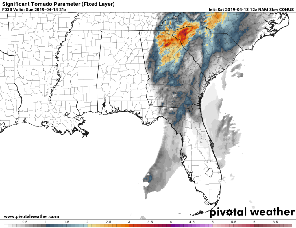
Just wanted to post another update from my post on Friday regarding the severe weather threat on Sunday. Not a ton has changed but it is becoming more clear how tomorrow will unfold. Overnight tonight (Saturday night) a line of strong thunderstorms will track across Alabama. As the line enters GA it should start to weaken as this line is way out ahead of the cold front. It should arrive in our area somewhere near the 10-11a hour (give or take) on Sunday. Then a new line will develop during the afternoon across northern Alabama and strengthen as it crosses northern GA. This should align when the severe supporting weather parameters are maxing out. So if anything I would say the severe threat has gone up just a tad.
The map I shared is the computer model generated STP (Significant Tornado Parameter) index. It’s basically a measure of different sorts of atmospheric conditions all mashed up together to come up with an index number. The higher the number the more favorable conditions for severe weather and tornadoes. Anything over 1 and you need to pay attention to the weather. For us this latest run of the NAM is suggesting an index value between 2-3 (give or take). What this all means is that we basically need to pay attention closely to the radar come Sunday afternoon. My thinking is highest threat for severe will occur in the 4p to 7p window. After that the front will move through and it will be all over.
So to recap, you weather watchers out there will see a strong line of storms tracking across AL tonight towards GA in the early AM. It should weaken as it reaches our area towards 10-11am. Then a new line will develop across northern AL early afternoon (Sunday) and strengthen as it tracks across north GA reaching us between the 4p-7p time window. Primary threat will be strong winds and hail. Tornado risk will also be present and I honestly wouldn’t be surprised if we end up under a tornado watch tomorrow afternoon.
With that in mind, enjoy today as showers will be few and far between.
Thanks for reading!
Jason
Good muggy Friday everyone!
Heat and humidity are upon us and that story will continue through Sunday. Despite the clouds and scattered showers we are easily above or normal high for this time of year of 70. The main talk and chatter out there right now is the potential for severe weather on Sunday. An area of low pressure is going to develop back in Texas and rapidly intensify and then track NE through Arkansas and Missouri. As it tracks to our north, it will drag a front across the southeast which will fire up plenty of showers and thunderstorms. There is a decent amount of wind shear with this system (winds changing direction and speed with height) which will aid in the development of severe level storms.
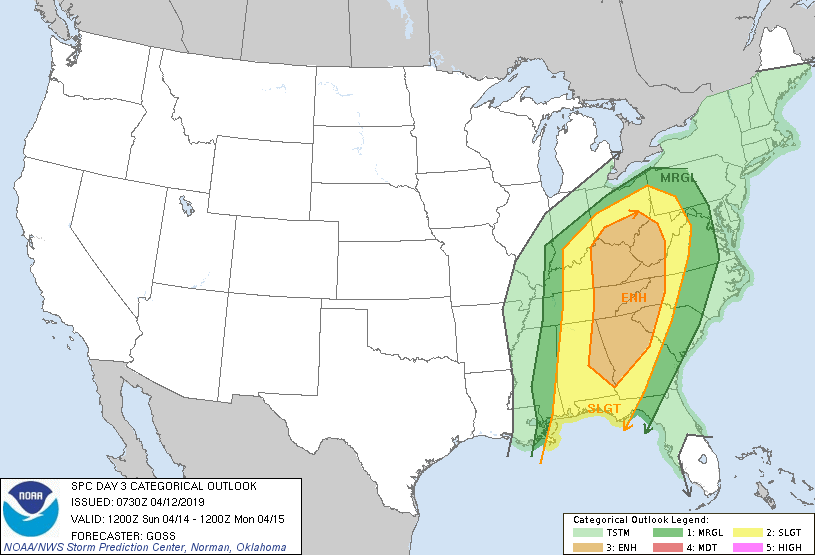
From the image below you can see that the Storm Prediction Center currently has us in the Enhanced risk category for severe weather on Sunday. While Enhanced is only in the middle of their scale, it is higher than what we normally see as typically we don’t see many instances higher than the Slight category.
So what does all mean exactly? Expect a higher than normal risk of a severe thunderstorm on Sunday. The mostly likely severe type of weather expected is strong winds and small hail. Now due to the wind shear with this system their is the risk of an isolated tornado or two that could develop anywhere across northern GA. So with that in mind, Sunday will be a radar watching day to see exactly where everything unfolds. When or where or even if a tornado will develop are simply impossible to predict. Just know that conditions will exist to allow for isolated tornado development. More often than not I simply shoot down our severe threats as we often have a wedge in place that saves the day. Sunday we will not have any sort of wedge so I’ll be keeping an eye to the sky.
With that in mind here is the forecast:
Today (Friday)…mostly cloudy and warm and humid with a 40 percent chance of a shower or thunderstorm. High in the upper 70s.
Saturday…partly to mostly cloudy with a 40 percent chance of a shower or thunderstorm. High in the upper 70s.
Sunday….read my post above.
Monday…sunny and breezy and cooler with a high in the low 60s.
Tuesday and Wednesday…partly cloudy with a high in the mid to upper 70s.
For those who have been asking about another freeze or frost, at this time I don’t see anything out there but we do have another decent cold front coming through on Friday the 19th. So if there is going to another chance it will be the few days after that.
Thanks for reading!
Jason
Showers are firing up as the upper level low center is starting to track across GA. Movement is slowly to the NE.
